Category: Mt. Charleston

Mt. Charleston Carpenter 1 Fire Photo -Update

July 8, 2013
carpenter1fire7-8-2013-1450

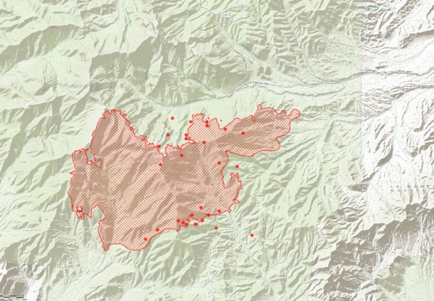
Mt. Charleston Carptener 1 Fire as of 2:50 pm 7/8/2013

Perimeter (red lines)

MODIS hot spot from satellite sensor, estimated location (1km). (Red Dots)

Source: ESRI http://www.esri.com/services/disaster-response/wildlandfire/user-maps
View Map: http://tmappsevents.esri.com/website/wildfire-responsive/index.html

carpenter1fire-7-8-2013-1450.jpg

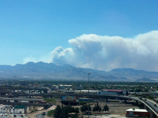
Mt. Charleston Carptener 1 Fire as of 2:50 pm 7/8/2013 darker smoke is visible shifted north from earlier.

Mt. Charleston Carptener 1 Fire

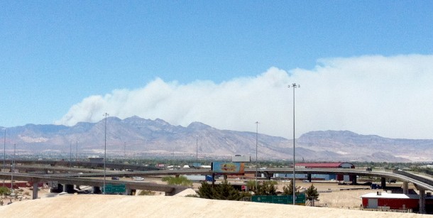
Mt. Charleston Carptener 1 Fire as of 12:30pm 7/8/2013

Mt. Charleston as seen from downtown Las Vegas.

Photos By: LasVegas360.com

Posted by: Vegas Info      catagory Hiking, Locals, Mt. Charleston comments Leave a comment

New Map of Carpenter 1 Fire in Mt. Charleston 10:00am

carpenterfire-7-8-2013-1056

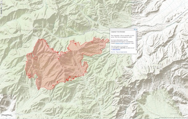
Hot Spot Map Carpenter Fire 1- Mt Charleston July 8, 2013 1:56 pm PST - Click to view Large Map

No structures have been lost. No injuries have occurred on the fire.

Fire control objectives include protection of the Trout, Lee and Kyle communities.

There are 18 crews on scene, 8 of which are Type 1 Hotshot crews, the most highly trained. The Hotshot crews we have are the same type as the crew recently lost in Arizona.

There are the following air assets on the fire:

  • 7 helicopters
  • 4 heavy air tankers
  • 39 engines
  • 10 water tenders
  • 18 hot shot crews
  • VLAT (Very Large Air Tanker. Based on a DC-10). It can drop 11,700 gallons per load.

Fire is located in some very rugged and in inaccessible areas. Engines and other motorized vehicles have limited access.

Perimeter (red lines)

MODIS hot spot from satellite sensor, estimated location (1km). (Red Dots)

Source: ESRI http://www.esri.com/services/disaster-response/wildlandfire/user-maps
View Map: http://tmappsevents.esri.com/website/wildfire-responsive/index.html

Posted by: Vegas Info      catagory Hiking, Locals, Mt. Charleston comments Leave a comment

Mt. Charleston: Lee Canyon

July 15, 2011

The lesser know area of Mount Charleston (Kyle Canyon) is the northern canyon of Lee Canyon, home the the Las Vegas Ski and Snowboard Resort. The hiking in this area is limited to the spectacular 6.1-mile Bristlecone Trail. Along this trail, hikers find ancient bristlecone trees, battered by cold temperatures and fierce wind. Some of these trees might be as old as 5,000 years!

The Lee Canyon Ski Area is born in 1964 when the US Forest Service issues a Special Use Permit in order to provide winter recreation options in Southern Nevada. From downtown Las Vegas: Take U.S. Highway 95 north approx. 30 miles to Hwy 156, Lee Canyon.  Follow Hwy 156 17 miles to the resort. The highway ends at Las Vegas Ski & Snowboard Resort.

Click for Hi-res 360 photo : Lee Canyon : copyright lasvegas360.com

On the Deer Creek Highway, which crosses from Lee Canyon to Kyle Canyon.

Click for Hi-res 360 photo : Lee Canyon : copyright lasvegas360.com

Lee Canyon Meadow- great place to play in the winter- lots of snow

Click for Hi-res 360 photo : Lee Canyon : copyright lasvegas360.com

End of the Road- Lee Canyon:Helicopter landing pad/parking lot
(Mummy Mountain in the background)

Click for Hi-res 360 photo : Lee Canyon : copyright lasvegas360.comAround Lee Canyon

Click for Hi-res 360 photo : Lee Canyon : copyright lasvegas360.comMummy Mountain is the 2nd highest peak in southern Nevada (11528 ft /3514 m)

Click for Hi-res 360 photo : Lee Canyon : copyright lasvegas360.comMore photos of the Lee Canyon Area

Click for Hi-res 360 photo : Lee Canyon : copyright lasvegas360.com Las Vegas Ski & Snowboard Resort (Summer)

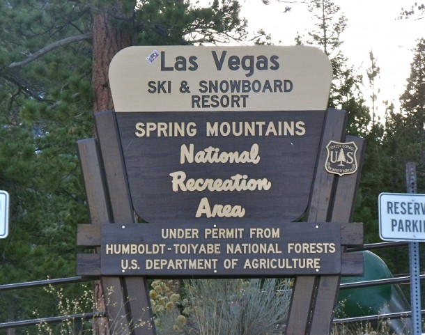
US Forest Service sign for Las Vegas Ski & Snowboard Resort

Posted by: Webmaster      catagory Hiking, Mt. Charleston comments 2 Comments

Mount Charleston / Lee Canyon

July 4, 2011

Click for Hi-Res 360: Lee Canyon: Mt. Charleston

Mount Charleston / Lee Canyon

The secret to keeping cool during the hot summer months is a trip to Mount Charleston, 45 miles north west of Las Vegas, take Highway 95, turn off onto Highway 157 at Kyle Canyon. Temperatures here average 20 to 30 degrees cooler than the city.

Located in the Toiyabe National Forest in Nevada. Mount Charleston stands at 11,918 feet and offers a tranquil contrast to the excitement and high energy of Las Vegas.The Mount Charleston Wilderness contains 18,000 acres of bristlecone pine, the most extensive stand of these ancient trees in the Intermountain Region. Its high, cool forested mountain landscape is in sharp contrast to the surrounding desert landscape, much like an oasis. There are numerous outdoor activities here such as horseback riding, hiking, camping and picnicking. Call the U.S. Forest Service for more information. 702.873.8800

For overnight accommodations indoors, try the Mount Charleston Hotel, at 2 Kyle Canyon Road. This hotel offers 60 rooms, 3 suites, a lounge, restaurant and a gift shop. 702.872.5500

About 4 miles away, the Mount Charleston Restaurant and Lounge offers hot food in typical mountainside fashion with a wood fireplace and picture windows looking out to the mountains. The restaurant has video slots, and a German polka band performs in the lounge on weekends and holidays.1 Oak Park Road 702.386.6899


Posted by: Webmaster      catagory Mt. Charleston, Off The Beaten Path comments Leave a comment