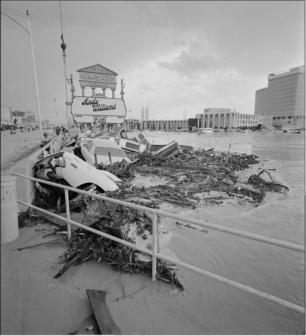
On the Strip, Caesars Palace Flood of July 3, 1975 – Las Vegas News Bureau.
Note: the following was originally printed in 2010.
35th Anniversary of The Caesars Palace Flood of July 3, 1975
Chris Stachelski NWS
Las Vegas Thirty-five years ago this summer one of the most significant flash flood events to ever occur in Las Vegas occurred on a Thursday afternoon right before the Fourth of July holiday weekend. Although this flood is often referred to as the Caesars Palace Flood since the devastation most often associated with it took place in the parking lot of the Caesars Palace casino, this event produced extensive flooding in other portions of Las Vegas and in North Las Vegas. At the time it occurred the Caesars Palace Flood was the most costly flooding disaster ever in the Las Vegas Valley with damage estimates placed at $4.5 million (in 1975 dollars).
The thunderstorm activity that occurred over far southern Nevada on the afternoon of July 3, 1975 was triggered by an increase in moisture that resulted from two factors. A moist southeast flow in the mid and upper levels of the atmosphere, typically associated with the monsoon, was already established in the southwestern United States by the morning hours of July 3rd. While this larger scale pattern typically brings enough moisture to trigger thunderstorms, the thunderstorm activity that would eventually develop on the afternoon of July 3rd was fueled by a surge of low-level moisture that came up the Colorado River Valley from the Gulf of California. Meteorologists often refer to this push of richer low-level moisture accompanied by such a wind direction up the Colorado River Valley during the summer months as a “Gulf Surge”. Gulf Surges have been noted for contributing to more active thunderstorm events and in those events often having storms that unleash heavy amounts of rainfall.
Shortly after 12 PM on July 3rd, thunderstorms began to develop around the southwest side of the Las Vegas Valley and then began to move northward. Thunderstorms continued to develop for the next few hours with activity being heaviest on the west side of the valley. Between 5 and 6 PM, the thunderstorms finally began to move northward away from the valley. The southeast side of the valley saw very little, if any, rainfall from the thunderstorms. As the thunderstorms moved northward across the west side of the Las Vegas Valley they unleashed heavy rain, with estimated totals in excess of 3 inches, as well as wind gusts of up to 58 mph. While much of the heaviest rain did fall on undeveloped land on the west side of the valley, residential neighborhoods in Las Vegas and North Las Vegas just west of Interstate 15 received at least a half an inch of rain.
The Las Vegas Valley slopes downward about 1000 feet from west to east and the heavy rain that did fall during this event was unleashed onto the higher west side of the valley. The natural drainage of the valley at this time was relatively unaltered and consisted of a series of alluvial fans containing washes that eventually drained eastward into Lake Mead. Thus while flooding on the west side of the valley resulted from a combination of heavy rain and drainage in primarily the form of runoff, flooding from Interstate 15 eastward was entirely from runoff. Flooding was first noted in the Las Vegas Creek during the afternoon of July 3rd, followed shortly after in the Flamingo and Tropicana Washes. In the Las Vegas Wash, flooding began on the upper reaches of the wash at North Las Vegas and then moved downstream. The flow of water then continued down the Las Vegas Wash before it emptied into Lake Mead. Floodwaters in the lower part of the Las Vegas Wash did not peak until the early morning hours of the 4th .
All-time peak flows based on records through 1975 were recorded on the Tropicana, Flamingo and Las Vegas Washes as well as Las Vegas Creek. Widespread flooding occurred in downtown Las Vegas, North Las Vegas and in neighborhoods just west of Interstate 15 and further east in Las Vegas along the Flamingo Wash. However, the most significant damage occurred on the Las Vegas Strip where the Flamingo Wash passed just north of the Caesars Palace and Flamingo casinos. Some 700 cars parked in a lot at Caesars were inundated when floodwaters swept down the wash and up against a bridge on Las Vegas Boulevard that went over the wash. Most of the cars parked here ignored a sign that warned of a flood threat in this area. While this was the most noted impact associated with this flood event, two men were killed North Las Vegas when they were swept away by floodwaters. Damage occurred to culverts and pavement along the Northshore Road in the Lake Mead National Recreation Area from water that surged downstream along the Las Vegas Wash. In metropolitan Las Vegas, extensive damage occurred with numerous homes and businesses flooded. Several vehicles were inundated by a surge of water or swept off roadways. Curbs, streets and lawns were flooded, eroded and covered with sediment. Numerous telephone poles were knocked over by the surge of water and erosion. Sewage plants were inundated and thus deactivated due to the influx of water and mud. Damage was estimated in 1975 dollars at $4.5 million.
The Caesars Palace Flood demonstrates how heavy rain falling in the headwaters of a drainage system, in this case washes, can result in flooding many miles away from where rain even occurs. Only 0.07 inch of rain fell at McCarran Airport during this event and a tenth of an inch was estimated by a bucket survey along the Flamingo Wash about a mile east of The Strip while three-quarters of an inch fell near where the Palms Casino stands today and as much as three inches was estimated in what is now Spring Valley. At this time there were no organized flood control measures in Las Vegas. In addition, real-time weather information such as radar, satellite and observations were extremely limited by today’s standards. Despite the limited technology, the NWS office in Las Vegas did warn of the flood around three and a half hours in advance. Although substantial improvements in weather forecasting and flood control have been made since 1975, floodwaters should never be underestimated.
Acknowledgements
Significant thanks are extended to Darryl Randerson who composed a paper on this event that was published in 1976. Additional thanks are extended to the Las Vegas Review-Journal for the use of images and to Barry Pierce of the National Weather Service in Las Vegas for reviewing this report.
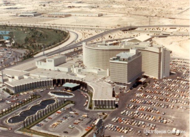
Caesars Palace in 1975 – Photo courtesy UNLV Special Collections.
The photo above shows Caesars Palace in 1975 likely prior to the flood event of July 3rd. This is very similar to what the layout of the Caesars property looked liked at the time the flood occurred. To the right of Caesars in this photo (the northern extent of the property) is the parking lot where as many as 700 cars were destroyed by the raging floodwaters of the Flamingo Wash. While Flamingo Wash is dry in this photo, it can be seen in the upper right where it extends out from a bridge that was built over it for Interstate 15. In the photo you can see how the wash comes right at a portion of the parking lot. Note that little development existed in the area just west of Caesars Palace (the upper portion of this photo). Today, this area is one of the most densely developed sections of Las Vegas.
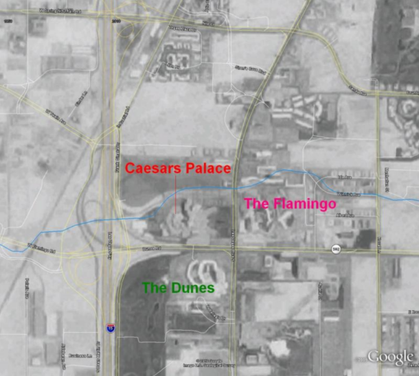
Google Earth image of the central Strip, 1977. Flamingo Wash is the blue line that runs across this image
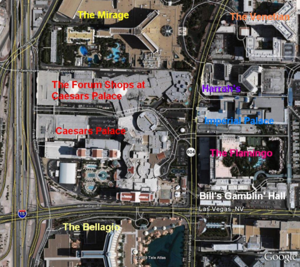
Google Earth image of the central Strip, 2010.
These aerial photographs show the central area of the Las Vegas Strip. In the top photograph, note how small of an area Caesars Palace covered in 1977. If you look closely you can make out some of the buildings then in today’s Caesars Palace. The Forum Shops now sit in the area where the parking lot was back in the 1970s. Of all of the neighbors Caesars had in the 1970s, only the Flamingo remains today. The Dunes Hotel was demolished in the mid 1990s and in 1998 the Bellagio opened in its place.
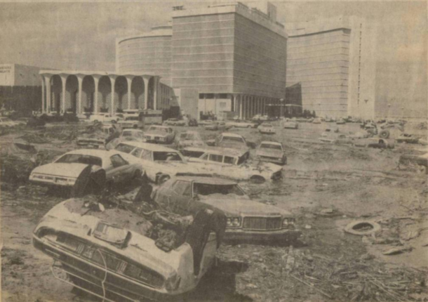
Wrecked cars are tossed across the parking lot at Caesars Palace after the flood. Photo Credit: Las Vegas Review-Journal.
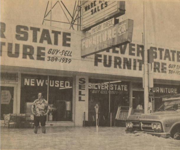
Floodwaters on North Main Street in Las Vegas. Photo Credit: Las Vegas Review-Journal.
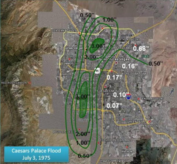
Caesars Palace Flood of July 3, 1975
Map of rainfall amounts From July 3, 1975. White numbers are actual values determined from rain gauges and bucket surveys. Green lines denote every half inch of rainfall measured. Black numbers denote values of green lines. Map background from Google Earth shows the Las Vegas Valley today. Values on the map were obtained from a report by Darryl Randerson done in 1976.
Additional Photos:
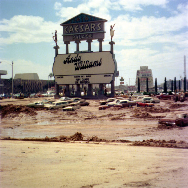
Flood-75
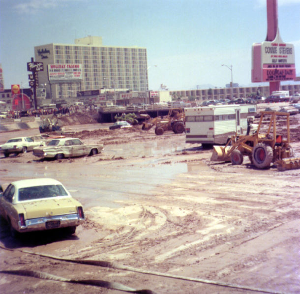
Photo Credits:
Review Journal, UNLV Special Collection, VintageLasVegas.com, Clark County Regional Flood Control District and Las Vegas News Bureau.
Like this:
Like Loading...
Vegas Info



 If you’re a passionate gambler who is trying to transition from land-based gambling to online casinos, you’ve two things to take into consideration: finding the perfect online casino and the best payment method to transfer your funds. And that’s where


